The Epic Lake Louise Circuit Hike

Intrepid hikers after an epic day at Lake Louise should look no further than the epic Lake Louise Circuit. It’s a 20 km loop that visits all the highlights of Lake Louise, offering extraordinary views of the lake.
It’s our suggested route that combines all the most popular hikes around Lake Louise. It starts at the Lake Louise lakeshore before making its way to Mirror Lake, the Little Beehive, Lake Agnes, The Big Beehive, The Plain of Six Glaciers, and finally back to where the hike began.
To our knowledge, this loop trail has no official name, so I guess we will call it the “Lake Louise Circuit Trail,” named by us. It’s now our favorite hike at Lake Louise, and we’ve done it almost every summer.

Where to Start The Lake Louise Circuit

There are multiple ways you can tackle this hike, but they all leave from the Lake Louise Lakeshore. You can venture to the Plain of Six Glaciers first, or make your way up the Lake Agnes Teahouse Trail. They go in opposite directions, so you’ll have to make this determination before you set out.
The best way, and the way we recommend for the best views, is to head up the Lake Agnes Trail, which is right in front of the Fairmont, to your right if you are looking at Mount Victoria. It’s also where most hikers will be heading, as Lake Agnes is the most popular trail in the area.
To The Little Beehive

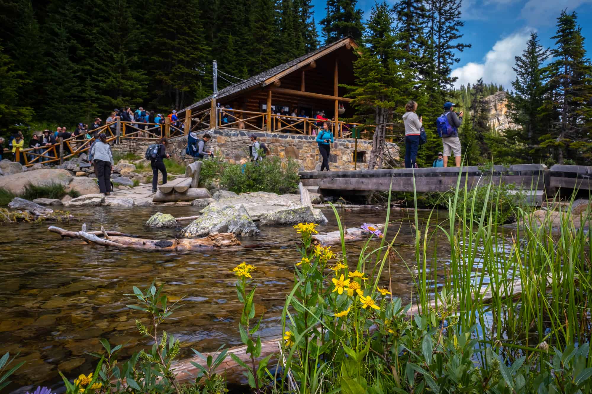
We recommend taking the trail to Lake Agnes and Mirror Lake first, as it offers better sights along the route. As you leave the crowded shore of Lake Louise, you’ll begin a gradual climb on a wide trail that follows a series of long switchbacks to the first stop.
You’ll get a few fleeting glimpses of Lake Louise until you’re surrounded by a spruce forest as the trail moves around to Mirror Lake and Lake Agnes. Mirror Lake is the first highlight, offering great views of the Big Beehive.

From the Mirror Lake lakeshore, you’ll be able to see where the Big Beehive gets its name from. After admiring the view, continue on the trail to the right of the lake. After about 500 metres of hiking, you’ll come to a fork in the trail.

One takes you directly to Lake Agnes, and the other goes up to the Little Beehive. You can take either, but we suggest heading up the Little Beehive to avoid any backtracking. Hike for another 1.5 km, gaining about 150 meters to reach the “summit” of the Little Beehive.

Enjoy the views over Lake Louise and out to Mount Fairview from the Little Beehive. On the lookout, there are a series of large rocks that make for a great place to take photos and clamber along the ridge edge. The view from the Little Beehive differs from the Big Beehive, and we find it generally sees fewer hikers, despite being easier.
Descend down to Lake Agnes

Once finished, there’s another trail that leads you to Lake Agnes. On this trail, you’ll lose about 100 meters over 500 meters back to Lake Agnes. Once at Lake Agnes, you can enjoy the stunning views here, and also enjoy a tea at the famed teahouse, if the line isn’t too long.
Climb the Big Beehive

After you have enjoyed your time at Lake Agnes, there’s a trail that goes around the northwest side of the lake that will take you to the Big Beehive. Once at the end of Lake Agne, there is a series of steep switchbacks gaining about 135 meters that will get you to the Big Beehive.


There are plenty of places to take in the view of Lake Louise below you from the Big Beehive. And if you find the right spot just past the gazebo, you’ll get a two-lake view of Lake Louise and Lake Agnes below.
Follow the Highline Trail

Now, from the Big Beehive, do not head back down the way you came. This may be the tricky part as the trail is a little hidden, but if you search, you’ll find a sign directing you to the Plain of Six Glaciers via the Highline Trail, about 200 meters below.
Descend the 200 meters through a series of switchbacks until you connect with the Highline Trail. Once you reach the trail, take a right and make your way to the Plain of Six Glaciers.

You’ll hike along the Highline Trail until it eventually merges with the Plain of Six Glaciers Trail. This part can feel a bit long, but the scenery is so beautiful you likely won’t notice.
To the Plain of Six Glaciers Teahouse


Once you connect to the Plain of Six Glaciers trail, you still have about 150 meters to gain over 1.3 km until you reach the teahouse. As you hike the trail, you can’t miss the famed teahouse on your right.

You’ve been hiking for a while at this point, so it’s probably time to stop for lunch or a snack. Thankfully, the Plain of Six Glaciers Teahouse is much less busy than Lake Agnes, and it’s often easier to get seated here. We recommend bringing cash for any items you may want to purchase.
Continue to the Plain of Six Glaciers Viewpoint

After your teahouse break, you have one last push to the Six Glaciers Viewpoint. While many people stop at the teahouse and turn around, we highly recommend continuing on to the viewpoint.
It’s less than 1.5 km away from the actual teahouse, but given the trail grade, it can feel tiring gaining those last 100 meters. Regardless, we’ve seen young and old continue on to get the beautiful view of the six glaciers. It will also give you an idea of how fast these glaciers are retreating.

You will cross the moraine debris left behind by retreating glaciers, particularly the Victoria Glacier that feeds Lake Louise. The trail becomes significantly steeper here and is not maintained past the teahouse. You will find more loose rock on the trail, and it can get chilly and windy as you near the glaciers, but the extra distance is worth it!
Head Back to Lake Louise


Once satisfied with the viewpoint, it’s time to descend, with no more ascending for the day (we promise). As you follow the Plain of Six Glaciers Trail back to the Lake Louise lakeshore, you’ll have grand views of the backside of Lake Louise and the famous Fairmont the entire time. Continue on this trail as you make your way back towards the crowds in front of the Chateau.
Extension Options

As it’s already a 20km day with quite a bit of elevation gain, it’s unlikely you’ll want extensions. However, just in case you do, there are two options we would recommend if you have the stamina for it.
- Mount Saint Piran: You can make your way up to the summit of Mount Saint Piran from the Little Beehive Trail. This adds another 450 meters of climbing to your day.
- Devil’s Thumb: You can head up to the Devil’s Thumb from the top of the Big Beehive Trail. This would add another 200 meters of climbing to your day. Devil’s Thumb is pretty popular and a bit of a scramble with some hands-on fun, so this is best left for hikers comfortable with steep ascents without a maintained trail.
Getting to Lake Louise

Although this whole circuit is over 20 km with 1000 meters of elevation gain, your struggle may not be the trail itself, but lining up how you’re going to get to Lake Louise. When we did this trail, we wanted to be the first ones on the Little Beehive watching the sun come up with coffee.
This meant being at Lake Louise by 5:30 a.m. We left Canmore by 4:30 a.m, and when we arrived at Lake Louise, the parking was almost full. To *hopefully* guarantee parking, you should aim to arrive at Lake Louise before 6am. Parking costs $42 per vehicle.
However, unless you want an early start, it’s best to use the Parks Canada shuttle to Lake Louise or a private operator like Fairview Limo.
Plan Your Trip to the Canadian Rockies

If you’re heading to Western Canada soon make sure to check out our interactive map with over 450 spots to help you plan!
- ✅ Hiking trails with links to trails & insider tips you won’t find online
- ✅ Our favorite photo spots, scenic views, waterfalls, must-visit attractions, and even swimming holes
- ✅ Our favorite restaurants, coffee shop & local spots that many skip.
- ✅ We add as we explore ourselves. That means we add new points every month!
- ✅ Map works with Google Maps!
- ✅ Pre built itineraries you can replicate,
- ✅ Discover spots via an ad-free interactive map and a grid, full of original content and videos
- ✅ Use on the go, mobile-first, offline-friendly, and made for the road.
- ✅ Local insights you won’t find on Google or AI – all in one place!


We are planning to do this hike in July and I am planning out what all will be in my backpack. Any idea how much water you packed? Is there anywhere to get water along the way (other than the teahouses)? Thanks!
I always hike with 2L+
We have a group of 10 that are going to do this hike in July. Could you email me the specific directions you took? We want to do both beehives, lakes, teahouses, and plain of 6 glaciers. Thanks!