How to Scramble The Onion on the Icefields Parkway

There is no shortage of hikes and scrambles along the Icefields Parkway that offer views of craggy peaks topped by glaciers, and the Onion Scramble is no exception. The scramble up to this unofficial peak places right next to the Wapta Icefield, the source of the Bow River. Expect to see glaciers, waterfalls, lakes, tarns, and unique rock formations.
The Onion Scramble

Key Stats

Length
20 km

Duration
5 – 9 hours

Elevation
850 meters

Difficulty
Hard

Trailhead
The Lodge at Bow Lake
GPX Tracks For The Onion Scramble
The Onion Scramble Route Description

The trail for the scramble takes the same path as the well-beaten route up to the Bow Hut. Pull off the Icefields Parkway, and start from the parking lot of the historic Num-ti-Jah Lodge (an Icefields Parkway hotel that is now called The Lodge at Bow Lake) and follow the trail along Bow Lake. The trail here winds along the shoreline and provides nice views of Bow Lake, Crowfoot Mountain, and a small alluvial floodplain coming from the glaciers high above.

Past the lake, you’ll come to a set of stairs that lead up to Bow Glacier Falls and the Bow Hut. A fork in the trail is marked with a sign delineating the path to Bow Hut. Follow the route to the Bow Hut, which continues to the left and down the ravine.
This leads to what may be the most challenging part of the scramble a considerable step up over a boulder that lies in the middle of the gorge. It’s a pretty awesome natural feature, and even Natasha at 5″ was able to manage her way up over the boulder with a boost.

Once you cross the boulder, the Bow Hut course is easy to follow. However, the terrain can be slow going and rough at times with a boulder field, stream crossings, and plenty of roots. The trail is not the best for trail running or tired legs. The path comes to a massive moraine basin that is flanked by enormous peaks and glaciers.


The basin may require some route-finding depending on the season and time of year snow levels, and streams vary. We climbed the Onion in late July after a big winter season and found the trail obscured by the snowpack.
A stream also crossed the approach, which required us to remove our shoes to travel. It was only ankle deep. Either way, you’ll head along the left side of the basin before crossing and ascending above the cliff bands on the right.
The trail up the right side of the basin is marked by cairns and obvious, so if it feels like you’re off-route, you’re correct.

The hike up to Bow Hut is a bit of a grind, but it is not overly challenging or in poor condition for a trail in the Rockies. Once above the slope, you’ll find yourself at the Bow Hut. It’s one of the most well-known and frequented huts in the ACC collection, used as a stop for the famous Wapta Icefield ski traverse.


From the Bow Hut, continue towards the toe of the glacier and the Onion. This is one of the most fascinating and enjoyable sections of the approach as you’ll pass over glacier source rock ribs, sparkling glacier pools, and dozens of steams. A trail to the glacier is worn by mountaineers, but the route up to the Onion quickly falls apart.
Nevertheless, the objective sits right in front of you, and it’s a fun section to pick your own line up to the peak. Not only did we find it entertaining, but it was manageable with a little more challenge than hiking off route. It would make for a great introductory scramble or for less experienced.

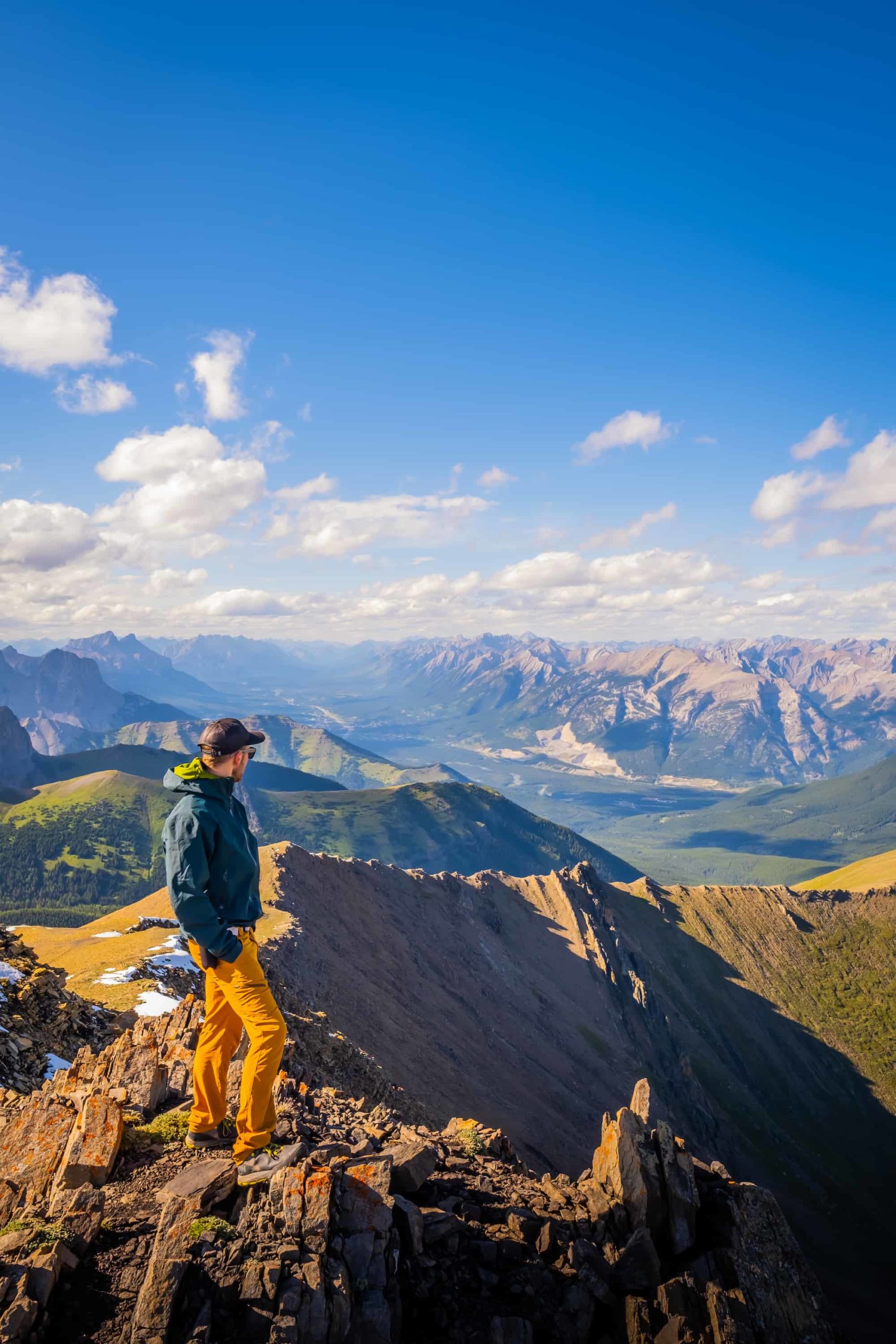
The section is slow going, so plan for another hour to reach the summit of the Onion. On top of the summit is a large plateau with expansive views of the Icefield. Notable peaks that can be seen are the dramatic St. Nicholas Peak, glacier-clad Mount Gordon, and Mount Thompson. We spent some time wandering around the summit, taking in views of Iceberg Lake and close-ups of the glaciers.


To return, head back down the Bow Hut and follow the same trail to Bow Lake. An alternate descent would be a detour from the Bow Hut to Iceberg Lake. There are cairns, and a path that leads to the lake, and the route looks easy enough. However, we chose not to make the addition as the sun was beginning to set due to a late start for evening light.


Gear We Recommend for Hiking in the Rockies

The vast majority of hikes and easy scrambles in the Rockies, you’ll find us in our trusty Salomon Speedcross.

Arc’teryx Cerium is our pick for the best down jacket. It’s incredibly light, and we bring it on almost every hike in the Rockies.

This nifty clip from Peak Design secures a camera to my backpack strap for easy reach. No more digging in the backpack!


20L feels like the ideal size for quick hikes and scrambles. We love the Nano from Gregory with a hydration reservoir.

There is not much cell service in the Canadian Rockies. In case of emergencies, we carry an emergency beacon with GPS.
How Hard is The Onion?

As capable hikers, we found The Onion to be relatively easy, albeit long. The most technical section of the hike/scramble involves crossing the rock ribs on the final push to the Onion summit. More than anything, anyone who approaches the trail should be prepared for a quiet trail in rough terrain. We saw no one else on the trail during our time on the Onion.
The Onion Duration

The duration of The Onion can vary significantly as there is a fair amount of distance, elevation, and route choices. There are definitely shorter Icefield Parkway hikes, I would plan for The Onion to take between six to nine hours. Of course, everyone’s hiking time varies, but an average pace falls in the middle of the suggested hike times. We completed it in six hours but could have completed it in a shorter time if we had trail ran.
When Can You Climb The Onion?

The Onion scramble was good to go around mid-July this year, but that was late as we had an abundance of snowfall. Generally, the mountain is in good shape for hiking from early July to September.
Advice on Hikes in the Canadian Rockies
- If this is your first time hiking in the Rockies take a conservative approach. Pick an adequate hike for your fitness, plan for plenty of time, pack water and food, and don’t be afraid to turn around.
- For long hikes, set a turnaround time at the departure. Any time we set out for an objective, I determine a time at which we need to turn around in order to arrive at the parking lot or campsite by dark. I would recommend not hiking in the dark as it’s easy to get lost, and it’s not fun in bear country.
- On that note, always carry bear spray if you plan to hike in the park. We carry ours in the neighborhood and bears have been known to stroll through town and busy parking lots. Always practice wildlife awareness when you’re on a trail, and please give animals space.
- In regards to times, keep in mind your mountain fitness, which is different from the gym. The low end of the times in this post is a constant fast pace uphill with little to no breaks and a brisk pace downhill. Most hikers should plan for a middle of the road time with the estimated duration.
- It’s also super important to know that there are limitations and to come prepared. These are very serious mountains, and it is easy to get in well over your head with life-threatening consequences.
- Lastly, a GPS tracker could save your life – it’s one of those backpacking essentials I like to have on me just in case I need to hit SOS. Alltrails is our favorite app to have on a hike. It shows the correct trail way, elevation, and other hiker reviews. We paid the subscription fee so that we could download all the data we needed to our phones. Best $3 (per month) ever spent!
What to Wear On a Hike?

The most basic principle of what to wear hiking is layering. Anyone who has spent time in the wilderness or mountains can attest that your temperature can fluctuate a lot on a hike. You can easily start off cool at the base of the mountain and get hot as soon as you begin moving.
The goal of hiking clothing is to help regulate your body temperature, element protection, and moisture management. Temperature management is best done through a layering system if you want to learn more about what to pack for a day hike or what to wear on a hike, you can see our full guide.


found your site from a pic you posted on Canadian Landscapes FB group – Thanks for the info and I’m going to look for more of your