How to Hike Tent Ridge Trail in Kananaskis Country
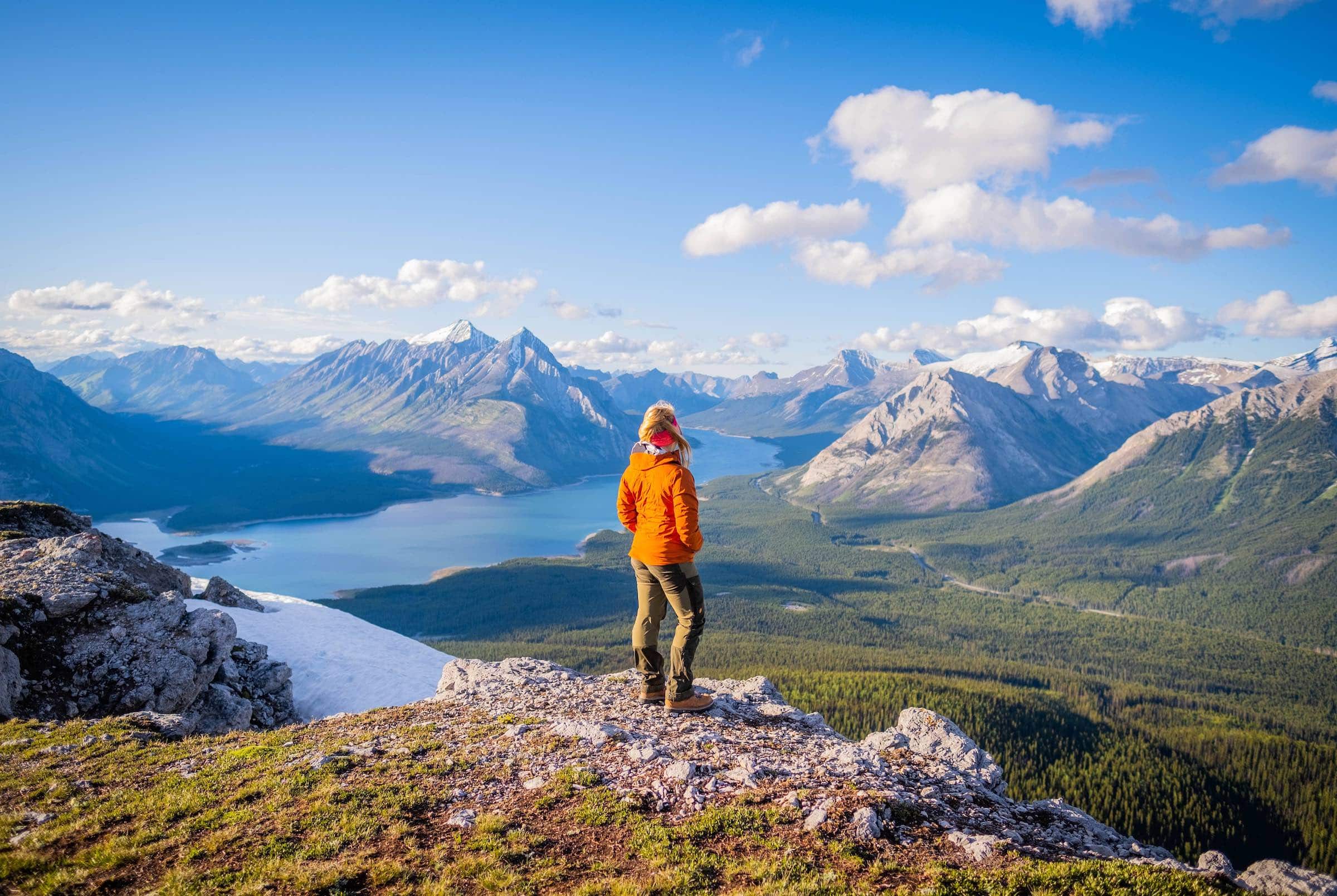
The Tent Ridge Horseshoe hike is one of my favorite hikes, not just in Kananaskis, but all of Alberta. Hikers climb to nearly 2500 meters for tremendous views over the Spray Lakes Reservoir and Mount Nestor.
Its location down the Smith Dorrien allows for a true wilderness setting away from Canmore and the front range. Hikers cross alpine meadows, larch forests, loose scree slopes, and narrow ridge walks. The views from the ridge are surreal, with a phenomenal panorama of the Spray Valley below.
It’s a stunning loop hike, only an hour’s drive from Canmore in the Spray Valley. Tent Ridge Horseshoe is tough to beat if you’re looking for a quick but moderately difficult hike with simply amazing views.
How to Hike Tent Ridge
Key Points

When is the Best Time To Hike Tent Ridge?

It’s best to hike Tent Ridge from late June to October. The ridge sits at a lower elevation and receives a fair amount of sunlight, so it dries out earlier than many hikes in the Rockies. It’s also a great larch hike come late September! We’ve hiked Tent Ridge a few times, and the photos in this article are from July, September, and October.
Tent Ridge Hike Route Description

The Tent Ridge Trailhead is along Mount Shark Road, not far past the Mount Engadine Lodge. Near the end of the trailhead, there is a small unofficial dirt parking lot, which can be found on Google Maps. We recommend completing the horseshoe in a clockwise loop, so you should head south from the car park.
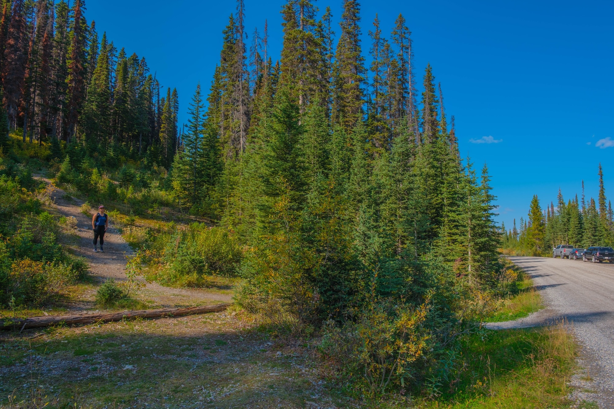
It’s a short walk along the gravel road to a wide trailhead through the dense forest. From the road, the trail begins a steady climb up through the forest. The trail is pretty well-trodden, so using GPS tracks should be straightforward.

Along the climb, you’ll catch glimpses of the reservoir and valley behind. Eventually, the trail leads into a large valley alongside a snow-fed brook. Above lies the ridge that you’ll ultimately gain.


From there, you’ll follow the established trail to the southwest that begins to climb the ridge. It follows a combination of switchbacks and straightforward climbing. It is easily the most arduous part of the hike.

Before gaining the ridge, there is a small section of scrambling with a slight exposure. It’s a mild exposure section, the only section on the route. If this is your first scramble, it may be a bit intimidating, but with caution, it’s doable for most.


After passing the scramble, the trail continues to gain the ridge. It is a bit of a grind, but you’ll reach the weather station after a while. Which is a small rocky summit that overlooks Tryst Lake. It’s the perfect spot to snack and put on extra layers, as the ridge is windy.


From here, you’ll continue downhill along the ridge before another large climb up to the saddle. A couple of lesser-used trails and routes from here continue to The Fist or down to Tryst Lake, but it’s best to stick to the ridge. The ridge combines solid rock and packed scree from thousands of hikers.


To follow the trail along the ridge is straightforward. It moves up and down and has several sections that offer some protection if you find yourself in inclement weather. We had some of our worst weather ever on a hike on Tent Ridge (twice!), as we saw lightning, high winds, rain, and snow.


Luckily it was short-lived, and we were able to hunker down in the rocks along the ridge. Although, there was some debate about backtracking and descending down to Tryst Lake. The good news was we were treated to some of the most incredible evening light we’ve experienced in the Rockies.

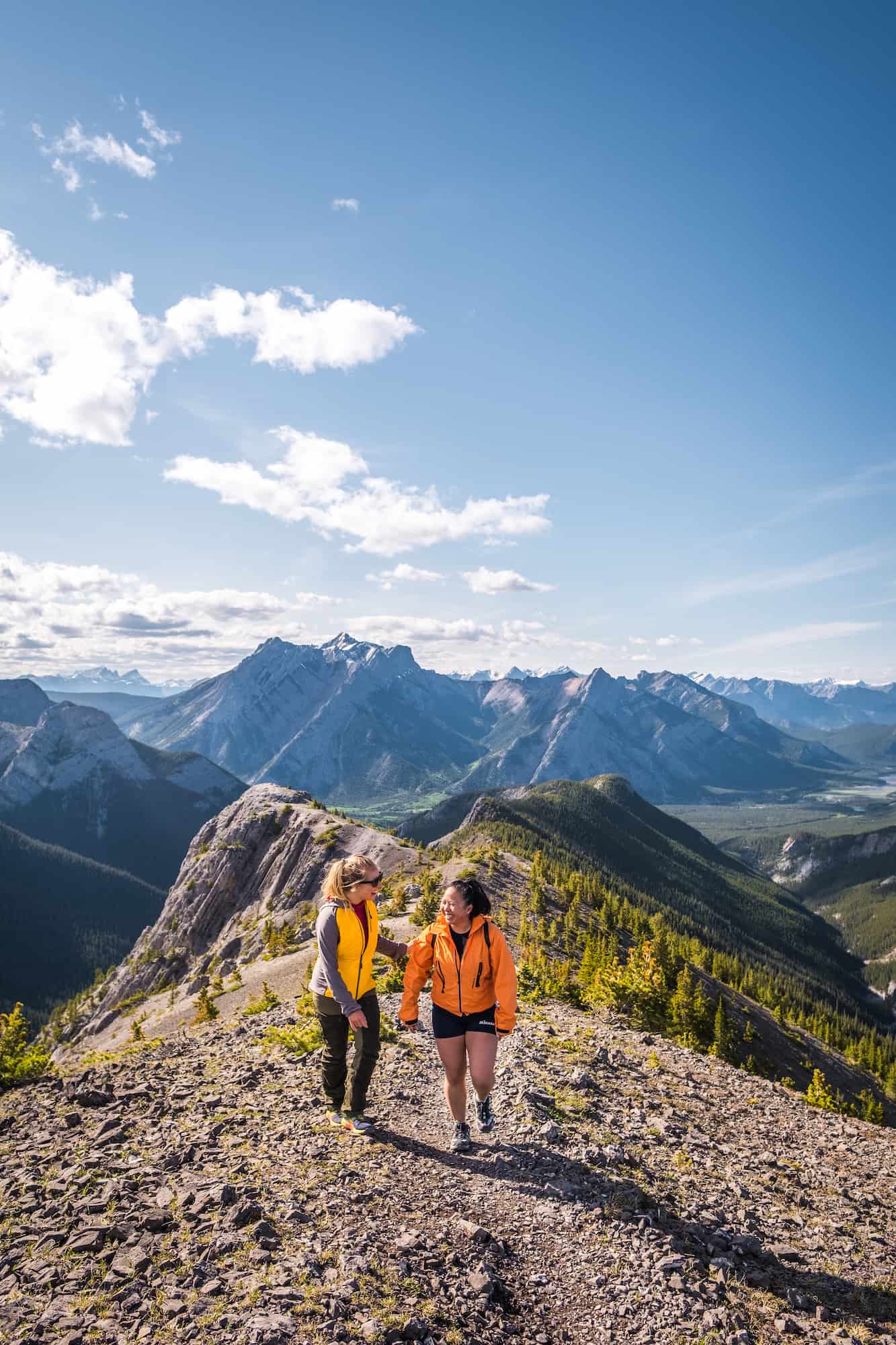
The trail is gorgeous, and deciding which direction to look is tough. That is until you reach the promontory and final viewpoint along the ridge. It affords sublime views of the Spray Reservoir down below. This is where you’ll want to sit down for awhile and pull the camera out!

From this viewpoint, you’ll find a series of steep switchbacks on the ridge’s northeast side. It’s steep and loose, but not as technical or exposed as the ascent route. It’s the perfect time to use a trekking pole to help you regain your balance.

The route remains steep until the treeline before it eventually levels off. However, it remains steep and moves over large roots and steep banks, so do take care. Eventually, the trail reaches an old logging road that leads back to Mount Shark Road and the car park.
Hiking Gear We Recommend

It’s tough to beat the comfort and stability of the Speedgoat. A more technical shoe would be the Salomon X Ultra.

It’s always jacket season in the Rockies. We always carry a down jacket on every adventure.

This nifty clip from Peak Design secures a camera to my backpack strap for easy reach. No more digging in the backpack!


A lightweight backpack is perfect for most hikes in the Rockies. We suggest keeping it simple and carrying the basics.

In case of emergencies, we carry a GPS-enabled emergency beacon. Solid for regular backcountry users.
How Long Does This Hike Take?

Tent Ridge Horseshoe is a 10-kilometer loop trail with over 800 meters of elevation gain. We are faster than average hikers, and this trail took us about 5 hours, with about 1-1.5 hours of photo stops as it was too beautiful and a very long lunch break near the satellite tower as we had some interesting weather roll through. We also waited a bit for the light to hit the peaks to capture some photos with evening light.

If we hadn’t taken photos or videos (or waited for great light at sunset), we would have been able to do this loop hike in 3 to 4 hours. On average, plan to be on the full trail between 4 and 6 hours, depending on your speed and fitness.
How Hard is the Tent Ridge Trail?


Although many guides rate this as hard, I would put it slightly above moderate. There are a few steep pitches that will have you panting, but I believe it’s rated as hard because of the scramble up (or down, depending on which way you go) from the ridge. I have seen people of all ages on this trail. The scramble is slightly exposed and very short-lived, but nothing too sketchy.
Which Way Should You Hike Tent Ridge?

Since this is a loop trail from the parking area, you can begin your ascent in two ways. Hiking Tent Ridge multiple times, we have now hiked both ways. The most obvious one is to the right of the parking area because it is more visible from where you park. This will take you up a steep climb, and you’ll move counterclockwise on the ridge, ending with a steep scramble down.

I do not recommend going this way. Instead, walk to the left of the parking lot until you find the trail and go clockwise for two reasons. Number one, you just have to hike the steep scramble up, not down, making it much less intimidating. Number two, because once you gain the ridge, you’ll have breathtaking 360° views of Spray Lakes in front of you, instead of behind, for the remainder of the ridgeline.
When Can You Enjoy the Tent Ridge Hike?


This trail is best between mid-June and mid-October, but this all depends on the year and snowpack. This area receives a lot of snow in the winter, and is considered dangerous avalanche terrain. It’s important that you do not attempt to climb Tent Ridge in the winter.
We hiked this trail on Canada Day weekend (July 1st). There were a few spots with slushy snow, but it was a dry trail for the most part. It’s still the mountains, though, and the weather changes rapidly. When we started this hike, it was a bright, sunny day. When we reached the top of the ridge, it was snowing, and the wind was howling, with no views at all.

Then, as we walked further along the ridge, the clouds passed, and the sun made a wonderful appearance again. Make sure that you’re fully prepared for any adventure out in the mountains, or you’ll have a miserable/dangerous time. Another time we hiked this was early October and there was LOTS of snow falling – you never know what the mountains have in store for you.
Tent Ridge is best avoided in the winter as it is an avalanche-prone area. Avalanches happen here, and deaths have tragically occurred in this area.
How Busy is the Tent Ridge Hike?

We set out for Tent Ridge on a beautiful weekday afternoon. When we reached the car park, there were about 10 other cars parked. We passed maybe 20 people on our way up. They were all hiking counter-clockwise direction – the one I don’t recommend.

Towards the end of the day, we found a few people who had just come up the counter-clockwise way for sunset, but not to hike the whole loop.
AllTrails rates this as a heavily trafficked trail, and I agree. You’ll have to time it right to have it to yourself, like we did, if you want complete solitude. Every time we have hiked Tent Ridge, we have started the hike in the afternoon and avoided any kind of crowding.
Weekends and holidays are busy. The best time to hike Tent Ridge is Monday through Friday at sunrise or sunset. It’s far from the busiest trail in the Rockies but also far from the quietest. Most foreign visitors stick to Banff, so you’ll mainly pass Albertans on the trail.

You also have to drive quite a ways on the Smith Dorrien Trail to reach it, past Mount Engadine Lodge, which probably keeps numbers down.
Should Dogs and Kids Do the Tent Ridge Hike?

Most of the trail is moderate, but there is a steep and short scramble either up or down. Only experienced trail dogs should tackle this, and young children with no scrambling experience may not enjoy it. However, any experienced child or pet who has done some hikes in the Rockies will have no issue.
Wildlife Awareness On Tent Ridge

- If you’re hiking in Kananaskis, you should practice proper wildlife awareness. In the region, there are frequent sightings of black bears, grizzly bears, moose, coyotes, and cougars. These animals are all potential threats to humans, and we should reduce our impact on their natural lives.
- Before any hike or walk in Banff National Park or Kananaskis Country, you need to have bear spray. Remember that the bear spray is worthless if it’s in your pack, and you’ll need to be able to grab it in two seconds or less in an emergency. We wear our bear sprays on our hips or on our running vests. If you’ve come to the park without bear spray, Valhalla Pure Outfitters and Canadian Tire in Canmore sell spray and holders. You can get employees at Valhalla to demonstrate how to use it properly.
- Always check the park websites for wildlife information (Parks Canada and AB Park), and then check again for notices at the trailhead. When you’re on the trail, make noise by banging hiking poles, talking, whistling, clapping, or singing. This is particularly important around blind bends and corners, which there are many at the start and end of the Tent Ridge hike. You’re through the deep woods during these times, and it’s prime time to sneak up on a bear. Once you’re on the ridge, you’re safer as you can see wildlife from afar, but still, don’t let your guard down, and keep the bear spray on you just in case.
Learn More


A Pass is Needed to Hike in Kananaskis
Visitors are required to hold a Kananaskis Conservation Pass, which covers Kananaskis and the Bow Valley Corridor. This pass is separate from the National Parks Pass needed to visit Banff and the other national parks. Passes may be purchased online and are attached to a license plate number. Requirements are around vehicles and parking, not the individual. This includes parking at the Canmore Nordic Center or Grassi Lakes.
Pass Prices
- Daily Pass: $15 (registers one vehicle)
- Annual Pass: $90 (registers two cars)
A Guide to Understanding the Kananaskis Conservation Pass
Things to do in Nearby Canmore

- Grab A Beer at the Tavern 1883: It doesn’t matter the season, but to end any day with a local craft beer and an appetizer in the stunning Rockies is the perfect day. We love Tavern 1883 and think it’s one of the best restaurants in Canmore.
- SUP: It is no secret that Canada has more stunning lakes than any other country. Canmore has a wide selection of waterways, and visitors can do many water activities there. One of those things that has made its way from the coast is stand-up paddleboarding.
- Grotto Canyon: Grotto Canyon is an easy Canmore hike that’s good year-round. Even in the winter, this famous canyon with rock art is possible to walk along the frozen creek. In the summer, it’s popular for families seeking to enjoy the narrow slot canyon and climbers looking to scale its walls. At only 4km in length, you can check this one off the list in an hour or two.
- Indoor Rock Climb at Elevation Place: Though rock climbing isn’t for the faint of heart, you don’t have to put your life at risk clinging to a sheer rock face thousands of feet up to experience it. That’s what they had in mind when they created Elevation Place – the place to go in Canmore to see what the climbing hype is about. It’s also a great place for expert-level climbers to practice their moves.
Other Kananaskis Country Hikes to Check Out
There are many more great hikes in the Kananaskis Country, or you can check out some awesome Banff hikes.
Hopefully, this will help you determine if the Tent Ridge hike is right for you. If you have any other questions,please comment or see our Canadian Rockies travel guide for more articles about photography spots, lakes, hikes, etc.
Plan Your Trip to the Canadian Rockies

If you’re heading to Western Canada soon make sure to check out our interactive map with over 450 spots to help you plan!
- ✅ Hiking trails with links to trails & insider tips you won’t find online
- ✅ Our favorite photo spots, scenic views, waterfalls, must-visit attractions, and even swimming holes
- ✅ Our favorite restaurants, coffee shop & local spots that many skip.
- ✅ We add as we explore ourselves. That means we add new points every month!
- ✅ Map works with Google Maps!
- ✅ Pre built itineraries you can replicate,
- ✅ Discover spots via an ad-free interactive map and a grid, full of original content and videos
- ✅ Use on the go, mobile-first, offline-friendly, and made for the road.
- ✅ Local insights you won’t find on Google or AI – all in one place!


Hi. I love your blog! One question regarding Tent Ridge hike.
We would like to to hike it with a baby (in the backpack carrier). So definitely not the whole loop, and would rather avoid the scrambling.
Do you think this is doable, anti-clockwise, and not even to the peak, just to the point where we can have beautiful view at the lake?
Definitely possible! Lots of people do this so they can skip the scramble section and still get the great views.
Paul would love to know if you ended up hiking this with your baby and any tips! Thanks!
Natasha and Cameron–any tips for hiking this with a baby? How long is the anticlockwise point where you have the beautiful view at the lake?
What month did you hike with these photos where there is still lots of snow near the ridge?
July 1
Did you prefer Tent Ridge or Sarrail Ridge via Rawson Lake?
Definitely Tent Ridge, it’s one of the best in the Canadian Rockies.
This trail looks absolutely stunning! I appreciate the detailed tips you provided, especially about the best times to hike and what to pack. Can’t wait to try Tent Ridge for myself!
Thank you for the detailed guide on the Tent Ridge Trail! The tips on what to pack and the description of the views really helped me plan my hike. I can’t wait to experience those stunning panoramas!
What time of day provides for the kind of lighting these images have. It sounds like you did this in the afternoon.
sunrise and sunset..