24 Fun Canmore Hikes and Trails from Easy to Hard
Interested in tackling some of the best Canmore hikes? The town’s locals and visitors are fortunate to have a wide selection of walks, hikes, and mountains to scramble. Canmore has around 70km of trails in town and is surrounded by many peaks that form the Bow Valley. In our opinion, Canmore is one of the best bases in the world for hiking, scrambling, and climbing.
That means there is plenty of room for exploration, as an extensive network links the various neighborhoods, parks, and points of interest. Here are our favorite Canmore hiking trails, starting with the easiest and working up to more challenging scrambles.
Our main goal with this article is to include hikes close to Canmore — not everything you can access from town. We have posts on our favorite Kananaskis and Banff hikes if you want more suggestions.
Easy Hikes & Walking Trails
Bow River Loop

- Difficulty: Easy
- Elevation: N/A
- Distance: 2 km
- Time: 20-50 minutes
- Note: This is a great walk for those staying in Downtown Canmore.
This is one of those super quick and easy hikes anyone can enjoy. The Bow River Loop is a pleasant circular walk around the Bow River outside the center of Canmore. The loop follows a gravel path along the Bow River and over two pedestrian bridges.
The highlight lies in the two bridges. The first bridge is at the end of 8th Avenue and offers fantastic views of a fork in the Bow River and the Three Sisters Mountains. You can even head down to the river shore and enjoy the views over the water. It’s one of our favorite spots to relax on a summer day.
The second bridge is the Engine Bridge, an old railway bridge once used by the town’s coal mining industry. It’s now an iconic pedestrian bridge and was featured in the TV series The Last of Us. The trail connects the two paths, and several offshoots offer exploration. We love to enjoy this Canmore walking trail with a cup of coffee from a local coffee shop.
Policeman’s Creek Boardwalk


- Difficulty: Easy
- Elevation: N/A
- Distance: 4 km
- Time: 40 minutes
- Note: A Conservation Pass is not needed for this walk.
Another one of our favorite Canmore walking trails! The raised boardwalk along Policeman’s Creek is a scenic and quintessential Canmore walk that is great for birding. It’s open and easily accessible year-round, making it perfect for experiencing the various seasons in Canmore. Policeman’s Creek is a small branch off the Bow River, and the walk stretches from the Canmore High School and down to the Spring Creek neighborhood.
It’s a lovely walk, but the most popular route is along the raised boardwalk from the Big Head on Main Street and down to Spring Creek. The short stroll is an excellent way to pass twenty minutes, take a few photos, and spot some birdlife with a coffee in hand. It’s always a treat! I particularly love this one around Christmastime, as you end up at The Malcolm Hotel to see their Festival of the Trees inside the hotel!
Want something a little more chill?
Done with hiking for the day and want something with views at a more relaxing pace? We love to recommend a Canmore Float Tour down the famous Bow River!
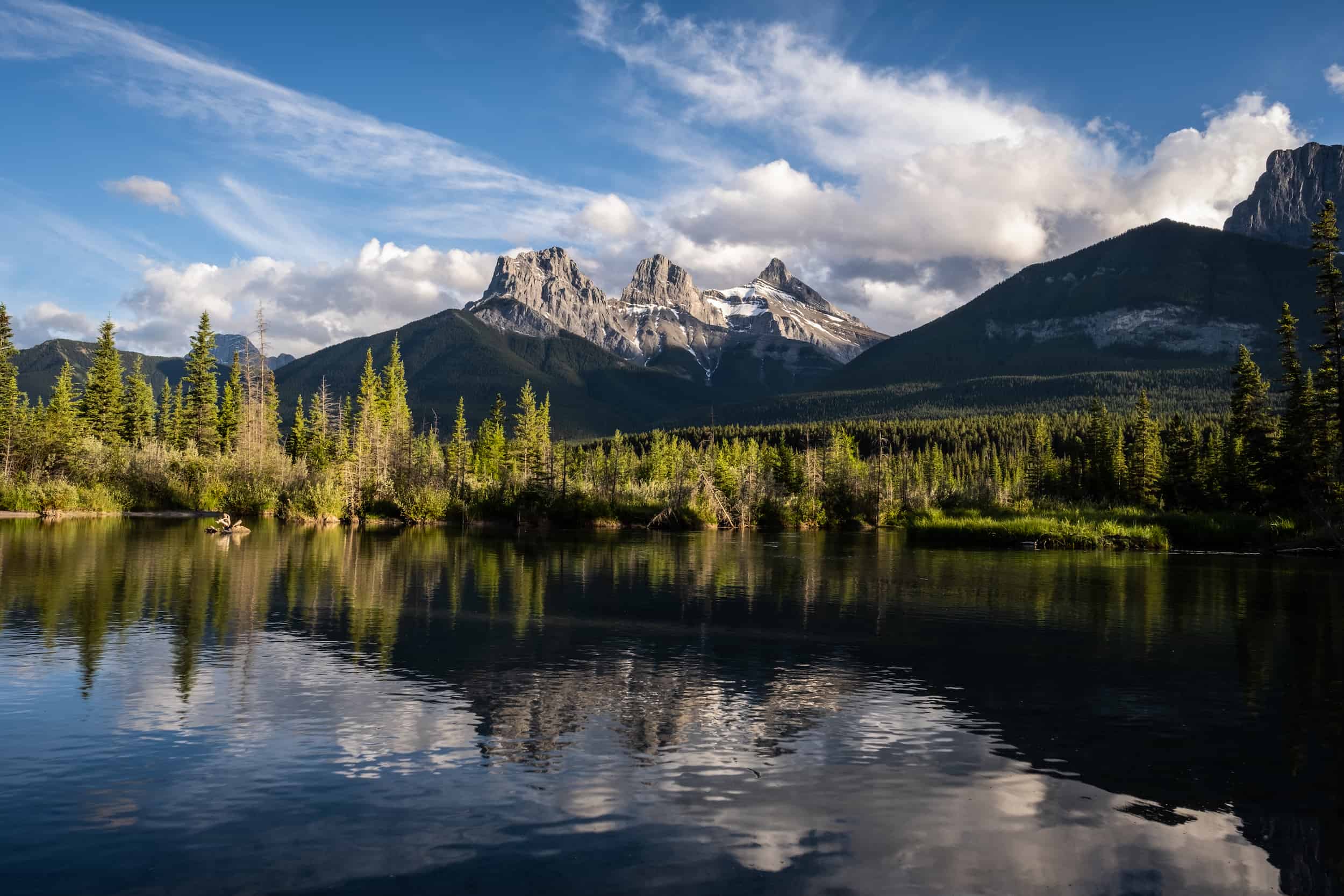
Three Sisters Viewpoint

- Difficulty: Easy
- Elevation: N/A
- Distance: 300 meters
- Time: 20 minutes
- Note: A Conservation Pass is not needed for this walk.
This is one of the easiest walking trails in town, and it ends with a beautiful reward. While you can see the Three Sisters from just about anywhere in Canmore, the most scenic view is from the Three Sisters viewpoint. It’s a five-minute walk to the photo point from the parking, and it’s well worth enjoying in the early morning or evening at any season.
It’s particularly popular with photographers as it’s an iconic spot in the Canadian Rockies. To reach the viewpoint, park at the town’s off-leash dog park near the helipad on the Bow Valley Trail. Cross the road and go under the train tracks, and you’ll find a path leading you to the photo point in about five minutes.
Rundle Forebay Reservoir (Canmore Reservoir)

- Difficulty: Easy
- Elevation: N/A
- Distance: 1-2 km
- Time: 30 minutes
- Note: A Conservation Pass is not needed for this walk.
The Rundle Forebay Reservoir, or Canmore Reservoir, is one of my favorite spots to relax in town. It’s a fantastic place to canoe, SUP, kayak, and even swim in the summer. The reservoir also supplies the Town of Canmore with water, so we are incredibly thankful for it.
Not only is it a great place to visit, but it’s one of the most beautiful as the magnificent Ha Ling Peak towers over it, and if you look to your left, you’ll get great views of the Little Sister, while if you look behind you you’ll get a fantastic view of Mount Rundle. You can easily walk right up to the lake and dip your toes in, but there is an almost hidden pathway to the left of the reservoir that you can walk along or bring the bike.
This pathway takes you to the end of the reservoir, where you can either turn around or take the Powerline Trail for a longer walk. The Powerline Trail will connect you to Quarry Lake or go even further to the Three Sisters Mountain Village. We frequently ride our bikes on the Powerline Trail when we’re looking for a quick workout from home.
Larch Island Interpretive Trail

- Difficulty: Easy
- Elevation: N/A
- Distance: 3.5 km
- Time: 40 minutes
- Note: A Conservation Pass is not needed for this walk.
Larch Island takes its name from the trees found along the creek and Bow River shoreline. To reach the island interpretative trail, continue past the Engine Bridge along the Bow River. It’s one of the best Canmore walks for everyone of all abilities.
The trail follows along the shoreline and is often quiet, so you’ll find a peaceful slice of nature. Turn left across a short footbridge that moves around the small island. In the summer months, you’ll find wildflowers and birdlife, while it’s a great trail to spot larches in the fall.
Benchlands Ridge Trail and Canmore Hoodoos

- Difficulty: Easy
- Elevation: 195 meters
- Distance: 4.0 km
- Time: 1 – 1.5 hours
- Note: A Conservation Pass is not needed for this walk.
The Benchlands Ridge Trail can be accessed from Downtown Canmore, but it does require walking over the busy highway overpass and up to Cougar Creek. The most pleasant experience would be to start from the Cougar Creek parking lot opposite the dog park. It’s a nice path that moves along a large bench and offers views across the Bow Valley to the Three Sisters.
It’s tough to argue with the panoramic views, although it is over the TransCanada, so expect a little road noise. At the end of the ridge are a few small hoodoos worth checking out. For the best experience, combine the trail with the Montane Trail to make a loop.
Quarry Lake

- Difficulty: Easy
- Elevation: 15 m
- Distance: 3 km
- Time: 30 min – 1 hr
- Note: A Conservation Pass is not needed for this walk, but paid parking is in effect if you have a vehicle.
Quarry Lake is the former site of the Canmore mine and a successful revitalization project beloved by the town’s residents. It’s been a local hangout for years now, but the secret has gotten out. Now, visitors flock to the park on weekend summer days to swim and enjoy the warm weather. It’s also popular for the off-leash dog park that neighbors Quarry Lake, perfect for a game of fetch or playing with your doggo.
The small lake has a nice loop you can walk around, and a plethora of trails extend out from the Quarry Lake into the surrounding neighborhoods and other trails like the Highline. If you venture out on the surrounding trails, keep in mind that several trails are biked-focused and managed by the local mountain bike organization; of course, hikers are welcome to walk the trails, but you’ll have to share the trail with mountain bikers.
Quarry Lake has ballooned in popularity, especially on weekends, and it’s been tough for even locals to find parking there anymore. The result is a paid parking system at Quarry Lake, and fines are issued by the Bylaw if you do not register your vehicle. With all the visitors comes plenty of trash that is left behind here. Please remember to pack out what you bring in and always Leave No Trace. There are plenty of bear-safe garbage bins around Quarry Lake where trash can be disposed of.
Three Sisters Pathway

- Difficulty: Easy
- Elevation: 100 meters
- Distance: 1 km – 15km
- Time: 30 mins – 4 hrs
- Note: A Conservation Pass is not needed for this walk.
This is our favorite walk in Canmore, plus it’s a great option for bikers and runners. Chances are you might even see us on the trail as it’s our access into town from our home in the Three Sisters Mountain Village. The trail is a mix of gravel and paved paths that follow the Bow River downstream to the Three Sisters. As the trail moves alongside the river, it passes several meadows, creeks, and forests.
We’ve seen a lot of wildlife along the trail, particularly birdlife in the river. There is also a good chance you’ll see some elk as they enjoy the grassy fields around the neighborhoods. These guys are a constant but welcome interruption to our walks around the neighborhood. As with anywhere in the Bow Valley, the mountain views are fabulous, and there are some nice, quiet spots to access the Bow River.
Grassi Lakes

- Difficulty: Easy
- Elevation: 165 meters
- Distance: 3.20 km
- Time: 1 – 2 hrs
- Note: A Conservation Pass is needed for this hike.
- Trailhead
Grassi Lakes is one of our favorites, and it’s the hike we’ve probably done the most in Canmore, as we live just down the road from the trailhead. The lakes are about five kilometers south of town and are easy to get to. You may want to consider packing some food for a picnic, as it’s one of the most picturesque places around Canmore. Stunning views of a nearby waterfall and the town of Canmore below present plenty of photo opportunities.
The mesmerizing colors of the water at Grassi Lakes are remarkable, as is the lake’s tranquility. Though there are other trails in the area, the trail is clearly marked, and you’ll know to turn around when you’ve reached the impassably steep part. There are two trails, an “easy” trail and a “hard” trail, but both are mild and considered easy during the summer season. Do not attempt the hard trail in the winter, as it gets extremely icy.
You can expect to reach Grassi Lakes in about 30 minutes of hiking. There are two lakes, multiple streams, bridges, and benches to enjoy nature. Don’t forget to take in the views over the Reservoir and town of Canmore. Although Grassi Lakes look tempting and refreshing, swimming is not allowed as it is a protected body of water.
Grotto Canyon
- Difficulty: Easy
- Elevation: 177 meters
- Distance: 5.3 km
- Time: 2 – 3 hrs
- Note: A Conservation Pass is needed for this hike.
- Trailhead
Grotto Canyon is an easy hike that’s good year-round. However, it’s even more popular in the winter, as you can walk along the frozen creek and see multiple frozen waterfalls. You may even spot an ice climber or two. If you plan to tackle Grotto Canyon in the winter, microspikes may be helpful as it can be very icy.
In the summertime, it’s popular for families seeking to enjoy the narrow slot canyon and climbers looking to scale its walls. At only 5km in length, you can check this one off the list in an hour or two, and you can always turn around whenever you are ready to call it quits. Keep your eye out for rock art along the walls.
Moderate Canmore Hikes
(For those with a few Canadian Rockies hikes under their belt!)
Lady Macdonald Teahouse

- Difficulty: Moderate
- Elevation: 1,015 meters
- Distance: 8.7 km
- Time: 1:30 – 5 hrs
- Note: Access to the Lady MacDonald hiking trail is regularly closed, so make sure to stay up to date before setting out. As construction progresses, future closures will be needed. See more info.
This is a popular Canmore hike with locals and visitors who want a quick workout or trail run. It’s a good early-season hike as the mountain receives a lot of direct sunlight, which melts the snow and has low avy risk late in the season. Once at the top, a large platform was the site of a planned teahouse that never came to be.
It is the perfect spot to take in the views of Canmore down below. Most hikers will stop at the “teahouse,” but you can continue to the true summit. However, the true summit requires some exposed scrambling along a narrow ridge. It’s a notorious
It is probably best to leave the summit for experienced hikers/scramblers. Most of the hike is spent in the forest, so I would choose another hike if you have peak summer hiking weather. Plus, the views are over the town and highway. However, we still enjoy it as it’s incredibly close to Canmore and gives unobstructed views of the Three Sisters.
The Highline

- Difficulty: Moderate
- Elevation: 300+ meters
- Distance: 13 – 25 km
- Time: 2 – 8 hours
The Highline is a worthwhile trail connecting Quarry Lake with the Three Sisters Mountain village via a shelf below the peaks of Ha Ling and Lawrence Grassi. As the trail climbs a few hundred meters, it winds through a lush forest full of birdlife and the occasional large mammal. It is largely used by mountain bikers, myself included, as it’s a great workout that can be done in an hour.
Despite the elevation gain, there is not much for views outside of a few avalanche paths/gullies that look down on the trail. It’s also worth mentioning the extensive network of illegal trails (pirate trails cut through wildlife corridors) that cut through the wildlife corridor, making it easy to get lost. We’ve stumbled across quite a few lost hikers in the area.
However, the main trail is largely self-explanatory. It is point-to-point with multiple options up and down, which explains the large variation in distance and time. We’d suggest most hikers skip it, but everyone has a different opinion of what they seek.
Wind Ridge

- Difficulty: Moderate
- Elevation: 800 meters
- Distance: 14.5 km
- Time: 4 – 6 hours
- Note: A Conservation Pass is needed for this hike.
- Trailhead
This hike leads away from Canmore as you leave the Bow Valley and head into the West Wind Valley. It should not be confused with West Wind Pass, a hike off the Smith Dorrien Highway that is easier than Wind Ridge. Wind Ridge is a gorgeous hike with tremendous views of Mount Lougheed and the beach side of the Three Sisters.
The hike starts near the Banff Gate Mountain Resort and trails through the woods on the West Wind Creek Trail. The trail starts off a bit monotonous through the trees, however once you exit the treeline you’ll get amazing views of Lougheed, Wind Tower, and Rimwall Summit. Continue following the trail, which gets incredibly steep in section. There’s a short scramble section, though you can bypass this on the right if you don’t like heights.
Once you get to the end of the Ridge, you’ll be treated to epic views of the backsides of the Three Sisters. If you are eager for more, you’ll notice there’s a trail to continue along the Wind Ridge Trail. Bring a jacket, its name doesn’t lie, and this ridge gets quite windy! Please respect the closure for wildlife from December 1st to June 15th.
Ha Ling Peak

- Difficulty: Moderate
- Elevation: 790 meters
- Distance: 7.9 km
- Time: 1:30 – 4 hrs
- Note: A Conservation Pass is needed for this hike.
- Trailhead
Ha Ling Peak is impossible to miss from Downtown Canmore and is the most popular peak in the area to climb. Nearly every local in town has likely clambered up to its peak, and over the years, it has grown to be one of the most popular hikes in the Canadian Rockies. Alberta Parks even invested in the trail with an extensive overhaul in 2019 that added steps and handrails.
While Ha Ling Peak may look daunting from Canmore, the hike up the backside is not much more than a physical challenge. The peak is the most popular in Canmore, which may detract some, but if you’re not comfortable in a wilderness setting on your own, there is some assurance in numbers.
Views from Ha Ling are tremendous, too, as you receive some wonderful views down the Goat Valley and Spray Valley. Ha Ling is particularly noteworthy as a great sunrise hike, and it’s possible to climb year-round.
Read’s Tower

- Length: 6.8km
- Duration: 3-5 hours
- Elevation Gain: 855m
- Difficulty: Moderate
- Note: A Conservation Pass is needed for this hike.
Read’s Tower is a very rewarding hike for its low exposure and minimal scrambling effort. It is perfect for those who want fantastic views over Spray Lakes but don’t want to put in a whole day’s effort to get up. This is only a four-hour round-trip hike, but you can keep going past to scramble Mount Sparrowhawk for a big mountain day.
The first hour or so of Read’s Tower winds through the forest. Get used to going uphill, as it never lets up once you start. Fight the rock slide and slabs uphill until they open up. From there, you’ll get a great view of both Mount Sparrowhawk and Read’s Tower. It’s a 45-minute to hour scree climb from the trail fork to the summit. Going up the treadmill of scree is brutal, but the scree run down is super fun and quick!
Difficult Hikes and Scrambles
(Light Scrambling is involved on most of these Canmore hiking trails.)
Pigeon Mountain

- Difficulty: Difficult
- Elevation: 920 meters
- Distance: 16 km
- Time: 4-6 hrs
- Note: A Conservation Pass is needed for this hike.
- Trailhead
The trailhead for Pigeon Mountain is just a 5-minute drive from the town of Canmore, and involves a pleasant hike to a true mountain summit that can be reached with no scrambling required.
Pigeon Mountain is named for flocks of pigeons spotted near it in 1858; however, it’s interesting to note that pigeons are not a native species and would not have been present in the Bow Valley at that time, so it’s unclear what bird was seen. While you may not see pigeons at the summit, this mountain offers a scenic hike through meadows with an exceptional view over Canmore from the summit.
The summit can be reached by parking at Banff Gate Mountain Resort and walking or biking the powerline trail until it veers off into the forest. Eventually, it opens up into a big, beautiful meadow. The trail gets steep as you get closer to the summit of Pigeon Mountain, but the views from the top are more than worth it.
East End of Rundle

- Difficulty: Moderate/Difficult
- Elevation: 877 meters
- Distance: 5.6 km
- Time: 3 – 6 hrs
- Note: A Conservation Pass is needed for this hike.
- Trailhead
Along with Ha Ling, the East End of Rundle hike is easily among the most popular hikes near Canmore. It also offers some of the best reward vs. effort in the area, with breathtaking views of Spray Valley and Ha Ling Peak. Its proximity to downtown Canmore and relative ease make it see heavy foot traffic. It’s a beautiful hike that offers visitors astonishing views over Canmore, the Bow Valley, and Ha Ling Peak.
Just because the East End of Rundle (or EEOR, or “Eeyore” as locals call it) is close to town doesn’t mean it’s an easy climb to the summit. A real physical challenge is involved, and only a fraction of hikers make it to the true summit since it involves some easy scrambling up a cliff band a few meters from the summit. Don’t forget to pack a summit beverage and sign the registry once at the top—along with Ha Ling Peak, the mountain is many hikers’ first summit in the Canadian Rockies!
Tent Ridge

- Difficulty: Moderate to Hard
- Length: 10.6km (6.6 miles)
- Duration: 3.5 – 6 hours
- Elevation Gain: 750m (2460ft)
- Note: A Conservation Pass is needed for this hike.
Tent Ridge is one of my favorite hikes in Alberta. It’s the furthest hike from Canmore on this list, but it’s well worth the drive. Located near Mount Engadine Lodge, this is a wonderful loop hike many visitors have on their lists. It’s been shared around social media like crazy, and it’s easy to see why. Our photos from a sunset years ago have been very popular, and the trail has since become very popular on weekends.
It’s the perfect hike with amazing views of the surrounding mountains and lakes. In summer, you’ll find wildflowers and wildlife, while plenty of yellow larches create a mesmerizing scene in the fall. Tent Ridge is a must-do if you’re looking for a quick but moderately difficult hike. Tent Ridge is a 10-kilometer loop trail.
Although AllTrails rates this as hard, I would put it more at a moderate. A few steep pitches will have you panting, but I believe the real reason it’s rated as hard is the scramble up (or down, depending on which way you go) from the ridge. Don’t worry, it’s a very simple scramble only slightly exposed in two sections but nothing too sketchy. We recommend tackling the loop clockwise.
Windtower

- Length: 9.8km
- Duration: 4-6 hours
- Elevation Gain: 898m
- Difficulty: Moderate to Hard
- Note: A Conservation Pass is needed for this hike.
Another one of my favorite hikes near Canmore is Windtower. Located along the Spray Lakes Road, Windtower provides amazing views over Spray Lakes and Canmore from the summit. It’s a moderate to hard hike with minimal scrambling. We completed this hike in four hours on a fantastic summer day and were rewarded with an epic sunset from the peak.
To hike Windtower, you’ll want to start across the street, alongside the road. You’ll hike in the treeline for the first 45 minutes or so until you reach West Wind Pass. If you want a nice, short, moderate hike, stop here and enjoy the views.
However, to conquer Windtower, you have at least an hour and some change from West Wind Pass, a bit of light scrambling, and a moderate incline to go. Once you finally reach the summit, enjoy the views, but don’t get too close to the edge – it’s a straight drop-off.
Little Lougheed

Mount Little Lougheed is one of the easiest summits in Kananaskis. Like nearby Windtower, it offers a fantastic view over the Spray Lakes. However, it’s much less popular than Tent Ridge, Ha Ling, or EEOR, mentioned above.
Though just because it’s one of the easiest summits doesn’t exactly make it easy. You’ll have to climb over 700 meters in under 4km, so in other words, this hike is very, very steep. The final push to the summit will certainly get you panting, and a pole would be helpful to get off the summit, as the steepness on the way down may cause you to lose your footing.
Regardless, once at the top, you’ll have unparalleled views of Mount Lougheed and Mount Sparrowhawk right in front of you.
Heart Mountain

If you’re driving down Highway 1 and see the shape of a heart in the mountain near Lac Des Arcs, you can rest assured knowing it was aptly named. The Heart Mountain Horseshoe Loop is a reliable early-season objective and a popular first scramble for many locals.
It features a great loop route, a long ridge walk, fantastic views, multiple peaks, and really nice rock for scrambling. It’s considered an easy scramble and a challenging hike, making it a great transition from hiking to scrambling. If you’ve never scrambled before, this might be a great intro for you.
Best of all, it’s easily accessible, situated above Lac des Arcs, just a 10-minute drive from Canmore. We tackled the Heart Mountain loop, knowing little more than the route from a topographic map, and left pleasantly surprised after a great day out in the mountains near Canmore.
Grotto Mountain

- Difficulty: Difficult
- Elevation: 1,352 meters
- Distance: 8.9 km
- Time: 2:30 – 7 hrs
Grotto Mountain may look unassuming, but the route up the peak packs a bit of a punch with a few technicalities and lots of elevation gain. A scramble up to the peak will offer impressive views over Canmore and the parries.
Those who choose to tackle this peak should come prepared for lots of scree and some hands-on scrambling. That being said, it’s an easy scramble, and many competent hikers should be able to tackle the objective. Despite spending a lot of time looking at the mountain, we’ve never felt like climbing to the top, hence the photo.
Middle Sister
- Difficulty: Difficult
- Elevation: 1,521 meters
- Distance: 17.1 km
- Time: 3:30 – 8 hrs
Hikers and scramblers can climb the Big or Middle Sister of the famous Three Sisters Peaks. The Middle Sister route is accessible only from Canmore, as the Big Sister ascent starts from the Smith-Dorrien Highway. It’s likely the most difficult scramble I feel comfortable recommending on this list, as it borders on a hike similar to Grotto Mountain.
To reach the peak, you begin your journey at the end of Three Sisters Mountain Village and ascend via Stewart Creek, which means many river rocks. After following the creek for several kilometers, the elevation starts to add up with a big scree bash up to the summit. This is a long day out, with little reward until you reach the summit. However, you get to say you’ve climbed one of the sisters!
A Pass is Needed to Hike in Kananaskis
Visitors are required to hold a Kananaskis Conservation Pass, which covers Kananaskis and the Bow Valley Corridor. This pass is separate from the National Parks Pass needed to visit Banff and the other national parks. Passes may be purchased online and are attached to a license plate number. Requirements are around vehicles and parking, not the individual. This includes parking at the Canmore Nordic Center or Grassi Lakes.
Pass Prices
- Daily Pass: $15 (registers one vehicle)
- Annual Pass: $90 (registers two cars)
A Guide to Understanding the Kananaskis Conservation Pass
Hiking Gear We Recommend

It’s tough to beat the comfort and stability of the Speedgoat. A more technical shoe would be the Salomon X Ultra.

It’s always jacket season in the Rockies. We always carry a down jacket on every adventure.

This nifty clip from Peak Design secures a camera to my backpack strap for easy reach. No more digging in the backpack!


A lightweight backpack is perfect for most hikes in the Rockies. We suggest keeping it simple and carrying the basics.

In case of emergencies, we carry a GPS-enabled emergency beacon. Solid for regular backcountry users.
Advice For These Canmore Hiking Trails

- Take a conservative approach if this is your first time hiking in the Rockies. Pick an adequate hike for your fitness level, plan for plenty of time, pack water and food and don’t be afraid to turn around. If you want to learn more about what to wear hiking we have a great post. We also have an excellent post on tips for new hikers.
- For long hikes, set a turnaround time at the departure. Whenever we set out for an objective, I determine when to turn around to arrive at the parking lot or campsite by dark. I recommend not hiking in the dark as it’s easy to get lost, and it’s not fun in bear country.
- Always carry bear spray if you plan to hike in the park. We have ours in the neighborhood as bears regularly stroll through town and busy parking lots. Always practice wildlife awareness on a trail, and please give animals space. You can buy bear spray at Canadian Tire or Valhalla in Canmore.
- Regarding times, keep in mind your mountain fitness, which is different from gym fitness. The low end of the times in this post is a constant fast pace uphill with little to no breaks and a brisk pace downhill. Most hikers should plan for a middle-of-the-road time with the estimated duration.
- A GPS could save your life as it’s one of those backpacking essentials I like to have on me just in case I need to hit SOS. Alltrails is our favorite app to have on a hike. It shows the correct trailway, elevation, and other hiker reviews. It’s not perfect by any means, but it is helpful to have on your phone as a backup.

If you’re heading to Western Canada soon make sure to check out our interactive map with over 450 spots to help you plan!
- ✅ Hiking trails with links to trails & insider tips you won’t find online
- ✅ Our favorite photo spots, scenic views, waterfalls, must-visit attractions, and even swimming holes
- ✅ Our favorite restaurants, coffee shop & local spots that many skip.
- ✅ We add as we explore ourselves. That means we add new points every month!
- ✅ Map works with Google Maps!
- ✅ Pre built itineraries you can replicate,
- ✅ Discover spots via an ad-free interactive map and a grid, full of original content and videos
- ✅ Use on the go, mobile-first, offline-friendly, and made for the road.
- ✅ Local insights you won’t find on Google or AI – all in one place!


Hi Cameron!
We are headed to Banff (staying in Canmore) in the second week of September this year. I love all the details you shared here! However, if we were to pick 3 walks/hikes to do in sequence, which ones would make better sense? My brother is from the Philippines so not used to elevation at all even though we will be visiting Whistler prior. Thank you!
Hi Maude,
This all depends on you and your hiking experience, fitness, and ability. I recommend going over the details of the km and elevation gain mentioned to see what you can handle. Of course we recommend looking at the photos too to see if any catch your eye and are must dos!
Great hiking ideas, thanks. We will be in Canmore on July 5th. for 6 nights, and were looking for nearby hikes to get us started before heading up into Banff NP. I see that some of the hikes we will need a ‘Conservation Pass’ What is this and how do we get one?
That information is listed at the bottom of this article. You can also read here: https://thebanffblog.com/kananaskis-conservation-pass/
Thank you for the great overview of all the walks available around Canmore!
Thanks for the great descriptions of these trails! We will be in Canmore from May 31-June 4. Are there specific moderate trails you’d recommend in order to avoid snow and ice?
Coming from Canmore, do you recommend Hwy 742 if it is open or should I just plan on going the long way via Hwy 40? I know 742 is gravel much of the way to West Wind Pass and other hikes.
It looks like we will need to plan a 2nd trip just for hiking!
Thank you!
We drive 742 all the time. Coming from Canmore it makes more sense, but it’s up to you and your vehicle.