Ha Ling Peak: How to Hike This Canmore CLASSIC

Ha Ling Peak is impossible to miss from downtown Canmore, and it is the most popular peak in the area to hike. Nearly every local in town has likely clambered up to its peak, and over the years, it has grown to be one of the most popular hikes in the Canadian Rockies.
While Ha Ling Peak may look daunting from Canmore, the hike up the backside is not much more than a physical challenge. The peak is likely the most popular in all of the Canadian Rockies, which may detract some, but if you’re not comfortable in a wilderness setting on your own, there is some assurance in numbers.
Ha Ling Hike Guide
Key Points
When is the Best Time To Hike Ha Ling Peak?

Ha Ling is possible year-round, but attention must be paid to avalanche cycles in winter and spring. We’ve hiked Ha Ling a few times, most recently in early April and again in early May, so there are photos in this article from both times that are noted.
A Pass is Needed to Hike in Kananaskis
Visitors are required to hold a Kananaskis Conservation Pass, which covers Kananaskis and the Bow Valley Corridor. This pass is separate from the National Parks Pass needed to visit Banff and the other national parks. Passes may be purchased online and are attached to a license plate number. Requirements are around vehicles and parking, not the individual. This includes parking at the Canmore Nordic Center or Grassi Lakes.
Pass Prices
- Daily Pass: $15 (registers one vehicle)
- Annual Pass: $90 (registers two cars)
A Guide to Understanding the Kananaskis Conservation Pass
Ha Ling Peak Description

Due to Alberta Parks’ closure in April 2020, we could not start from the usual parking lot off the Smith Dorrien Highway. Instead, our journey began from our home in Canmore, which added an extra 450 meters and 16km to the hike, a proper day out. It’s a nice challenge and provides a small Canmore Triple Crown or Quad taste. Plus, it felt like a rare opportunity to have the trail and summit to ourselves.
Though now that we are past pandemic times, this is not necessary and hikers can begin their trek directly from the Goat Creek Parking lot, across the street from the Ha Ling Trailhead.
In 2020, we made our way up the Highline for the approach before connecting to the Riders of Rohan on our way to Smith Dorrien. It definitely beat the dusty long highway or the well-trodden path of Grassi Lakes, but made for a very long day.


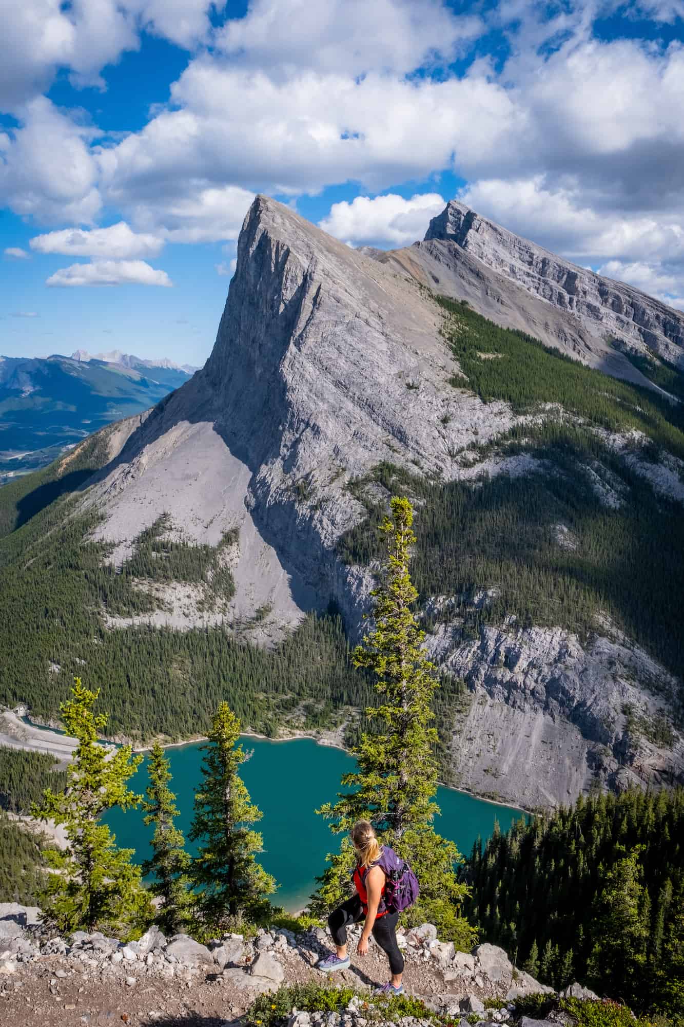
Most hikers will start right from the Goat Creek Parking Lot. As you make your way around Whiteman’s Pond towards the parking lot, whether on foot or by car, you get a spectacular view of the profile of Ha Ling. It’s a view that made the East End of Rundle hike a classic and popular on social media platforms.

Once past Whiteman’s Pond, parking takes place at the Goat Creek day-use area, which is now a large paved parking lot to accommodate all the visitors accessing the area.

The trailhead begins across the road from the parking lot, across the dam bridge at the end of Whiteman’s Pond. It’s an easy one to find, along with several signs.
The old trail up to the top of Ha Ling was a bit of a mess through the woods due to foot traffic erosion. However, at the end of 2019, Alberta Parks unveiled a new trail that was significantly upgraded with even grading, switchbacks, steps, and handrails in certain locations costing nearly $850,000. They continued upgrading it through a few more closures in 2022 and early 2023.
Not only was it meant to improve the user experience, but its more important goal was to control soil erosion and protect the endangered Whitebark Pine.

The improvement has increased the safety of the trail, but make no mistake—it’s still a tough physical challenge for many. Once you enter the trailhead and make your way through the forest, it’s a constant uphill climb to the summit. It’s probably best to pace yourself throughout the hike.
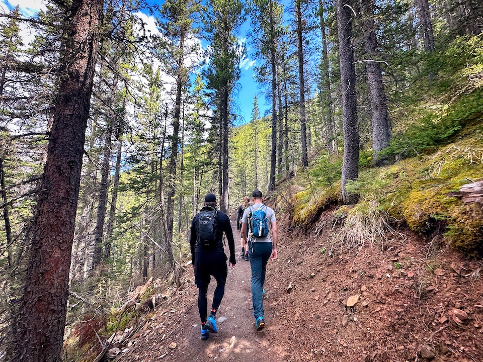
The outset through the forest will be largely uneventful as there are no views until a couple kilometers up when the forest starts to break apart. You’ll first be greeted with glimpses of the Spray Valley and the Goat View Peak. The view is only a small taste of what lies further up the mountain.


The switchbacks and climb through the forest continue until you’ll reach a viewpoint with a viewing platform with chains and steps. From here, you can enjoy great views of Rundle, the Bow Valley, and Spray Valley. It’s a good point to turn around if the hike is proving too difficult, but if you have the energy, we highly suggest you continue to the top for 360-degree views.


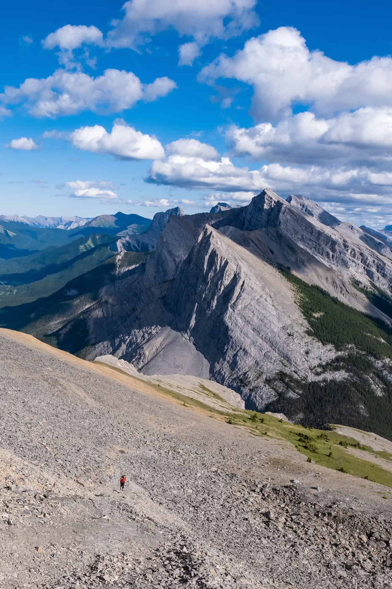
The final push moves through an increasingly thin forest that allows views of Miner’s Peak and Lawrence Grassi. From the viewpoint, it’s a relatively easy uphill grade until the final climb up the steep track to the saddle and summit.
Trail improvements include a few areas to hold onto a chain for balance, and two sets of steps over loose scree, which we didn’t get to take advantage of in winter conditions during the spring, though they are very helpful when trail conditions dry out and the seasons change.


From the last of the steps, you leave the forest behind, and the summit is in clear view to the hiker’s left. The last bit is almost an easy scramble, as there is no clearly defined trail to the summit across the scree and rock saddle. You definitely don’t have to use your hands, making Ha Ling a hike rather than a scramble. However, depending on your hiking style, there may be sections where you find using your hands beneficial.


It may take 10-15 minutes to cross the rocks, but take care and watch your step over the rocks. Despite all of the improved safety measures, a hiker still managed to break their ankle on the first day of the new trail’s opening in 2019 and required search and rescue.


Once on the summit, the views of the region are expansive. You can see up the length of the Bow Valley to the distant Cascade Mountain. The jagged peaks of the Rockies feel innumerable, and forested valleys are a sight to be seen.


If Ha Ling is your first peak in the Canadian Rockies, it will take your breath away. Many declare it the best sight they have ever seen. In our opinion, it’s just the tip of the iceberg for great Canadian Rockies summits and a great way to become acquainted with hiking/scrambling/mountaineering in this spectacular part of the world.
It’s often windy on the summit, so be prepared with an extra layer if you plan to spend much time there to enjoy the views. Also, the hike is an out-and-back one, so you’ll need to descend the same way you ascended unless you feel like adding on nearby Miner’s Peak for an extra half hour!

Head back the same way you came, and watch your footing on the way down from the summit, as it’s steep and there is loose rock. Once past the stairs, the descent is easy peasy. We descended from the summit in 45 minutes at a leisurely pace.
Tips To Hike Ha Ling Peak

- Head to Alberta Parks for the latest notices and trail conditions.
- You are in bear country! Be sure to carry bear spray and be bear aware. We have some tips down below about wildlife awareness.
- The Goat Creek parking lot is one of the most popular in Kananaskis Country. Arrive early or late on weekends to ensure a parking spot.
- If you’re climbing Ha Ling Peak in the spring or winter it’s a good idea to be aware of avalanche conditions. You can view the report on Avalanche Canada. There are several avalanche paths that cross the trail up to the summit.
- When moving in the mountains, it is NEVER a good idea to send rocks down the mountain. There are several climbing routes up the rock face of Ha Ling, so be mindful not to send a rock down either side.
- Dogs are allowed on the trail and must be kept on leash at all times.
- Bikes are not allowed on the trail. If you’d like to bike in the area, the High Rockies Trail and Goat Creek are both very popular and wonderful rides.
- There are bathrooms at the Goat Creek parking lot. Since the Ha Ling Peak trail can be very busy it may be difficult to step into a bush on the trail during busy periods.
- Since you’re directly over Canmore, the hike has cell phone service for the majority of the hike.
- Even in the summer, it can be very cold and windy. We recommend you pack layers for any hike. It also never hurts to have a toque and gloves as they’re lightweight and add a ton of warmth.
- A summit beer or treat is never a bad idea as a reward for when you reach the top! Remember to pack everything out!
Hiking Gear We Recommend

It’s tough to beat the comfort and stability of the Speedgoat. A more technical shoe would be the Salomon X Ultra.

It’s always jacket season in the Rockies. We always carry a down jacket on every adventure.

This nifty clip from Peak Design secures a camera to my backpack strap for easy reach. No more digging in the backpack!


A lightweight backpack is perfect for most hikes in the Rockies. We suggest keeping it simple and carrying the basics.

In case of emergencies, we carry a GPS-enabled emergency beacon. Solid for regular backcountry users.
Parking For Ha Ling Peak


Parking for Ha Ling Peak is at the Goat Creek Day Area. It’s pretty common for the parking lot to fill up on weekends as it’s a very popular hike. If that is the case, you can park further down along the road near Whiteman’s Pond if there are spaces, or just go for another hike in Kananaskis Country. For hikers, our personal favorite is Tent Ridge.
When Can You Hike Ha Ling Peak?

In some ways, Ha Ling Peak is a year-round objective. Just about every week of the year, someone or some group clambers up to the top of the peak. That being said, it does cross a couple of avalanche paths. So if you choose to hike/snowshoe it in winter/spring conditions, you should be aware of avalanche conditions and the forecast.

The good news is that the elevation and sun exposure melt the snow much faster on Ha Ling than on many other trails. It’s typically a good early-season objective, but be prepared to deal with a little ice, snow, or mud. If you have them, microspikes are a huge help. I even found my ice ax useful for the top section in the winter. However, it’s not needed.
Summer is the ideal time to hike up Ha Ling Peak; however, the trail is a bit hectic on nice days, so we recommend an Alpine start or a late afternoon start. On a typical summer day, over a thousand hikers visit, making it one of the most frequented trails in all the Alberta Parks.
Ha Ling Peak Map
If you’d like a paper map of Ha Ling Peak and the surrounding area, you can check out these maps: “Canmore and Kananaskis Village” and “Banff & Mount Assiniboine.”
Alternatively, you can use the Alltrails app to download a map of the route up to Ha Ling Peak. If you want to learn more about scrambles in the Rockies and Ha Ling Peak, check out the bible of scrambles, Alan Kane’s Scrambles in the Canadian Rockies.
How Long Does it Take to Hike Ha Ling Peak?

Ha Ling Peak is a short and sweet summit that doesn’t require a full day of hiking. This makes it ideal for visitors to the area who don’t want to spend their whole day on the trail. Average times on the hike are between 3 and 5 hours round trip. Of course, it’s entirely possible to spend longer on the trail, while anything shorter requires some trail running.
We’ve hiked Ha Ling several times. On our most recent journey, we motored along on the way up and made it to the summit in 1.5 hours. It took our group 55 minutes to descend, and we had a 30-minute summit stop.
How Hard is it to Hike Ha Ling Peak?

The hike is steep and constant, so be prepared for a workout on your way to the peak. From the parking lot, you gain about 750 meters in 3.6 km. The trail is physically difficult, but it contains no technical difficulties. It’s tough to be considered a scramble to the summit, and with the recent trail improvements, the hike is much easier.
Make no mistake, it is steep as the trail starts at 1,660 meters and climbs to the summit of Ha Ling Peak at 2,408 meters. On average, you’ll gain more than 200 meters every kilometer. All that being said, we find Ha Ling Peak to be one of the easiest mountains to summit in the Canadian Rockies.
Should Dogs & Kids Hike Ha Ling Peak?

Both dogs and experienced kids should be able to handle Ha Ling Peak. Every child and dog is different, so you should assess their physical capability. The hike gains 200 meters every kilometer, so it is a physical challenge, though we saw plenty of doggos on the trail and even a few young children.
Additionally, the saddle and summit are exposed to large cliffs, so they need to be well-behaved and obedient. Please keep your dog on a leash, as bears and even cougars are around. It’s the law and can be detrimental to other hikers, the dog, and wildlife.
A few years ago, a negligent hiker let their dog off-leash, which resulted in the dog being eaten by a cougar. Alberta Parks was then forced to euthanize the cougar due to predatory behavior displayed to dogs, which the animal then viewed as prey. Don’t be that person.
History of Ha Ling (Chinaman’s Peak)
The name Ha Ling Peak certainly stands out in the Canadian Rockies. Naturally, with a name like that, there is a story to the origin. Back in 1896, a Chinese cook working for the Canadian Pacific Railroad Company was bet $50 he could make it to the summit of the nearby mountain in under 10 hours.
To everyone’s surprise, he not only succeeded but, after setting out in the morning, was back in time for lunch. After the feat, the peak was referred to as Chinaman’s Peak until 1980, when it officially received the name. Chinaman’s Peak did not last long, as in 1997, the name was changed to Ha Ling Peak to be less derogatory.
Wildlife Awareness on The Hike
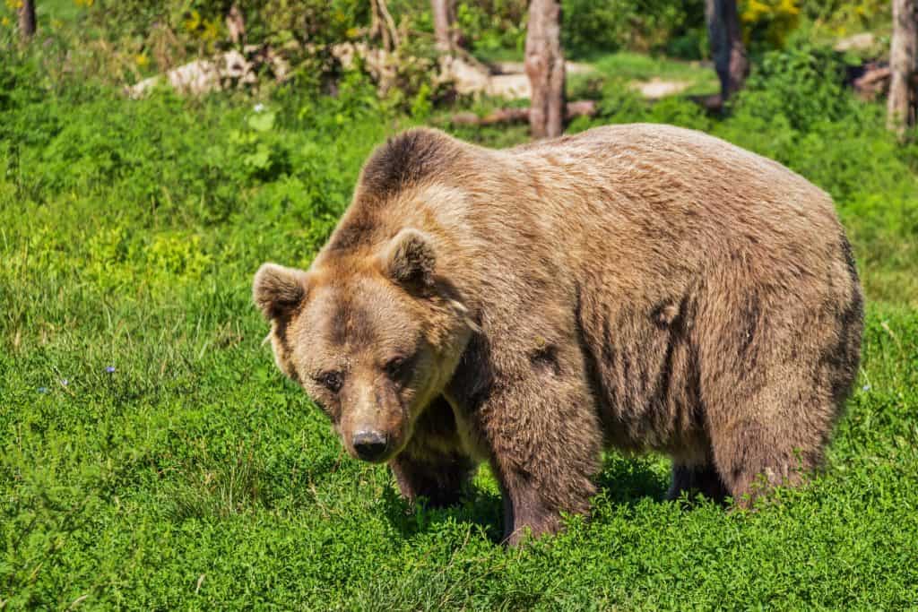
If you’re hiking in Kananaskis, you should practice proper wildlife awareness. Black bears, grizzly bears, moose, coyotes, and cougars are frequently sighted in the region. They are all potential threats to humans, and we should reduce our impact on their natural lives.
Before any hike or walk in the Canadian Rockies, you need to have bear spray. Remember that the spray is worthless if it’s in your pack. You’ll need to be able to grab it in two seconds or less in an emergency. We wear our bear sprays on our hips.
The likelihood of seeing wildlife on this trail is high, though it is very busy, which deters wildlife a bit. It is a heavily trafficked trail, but bear sightings have occurred. The meadow and valley are prime grizzly habitats, and the trail has been closed in the past due to bear activity.
When you’re on the trail, make noise by banging hiking poles, talking, whistling, clapping, or singing. This is particularly important around blind bends and corners. You’re through the deep woods during these times, and it’s prime time to sneak up on a bear. Once you’re at the summit, you’re safer as you can see wildlife from afar, but still, don’t let your guard down and keep the bear spray on you just in case.
As always, while hiking, you need to stay alert, travel in a group, mind children and pets, and finally carrying bear spray and knowing how to use it. If you’ve come to the park without bear spray, Valhalla Pure Outfitters in town sells spray and holders with employees who will demonstrate how to use them properly.
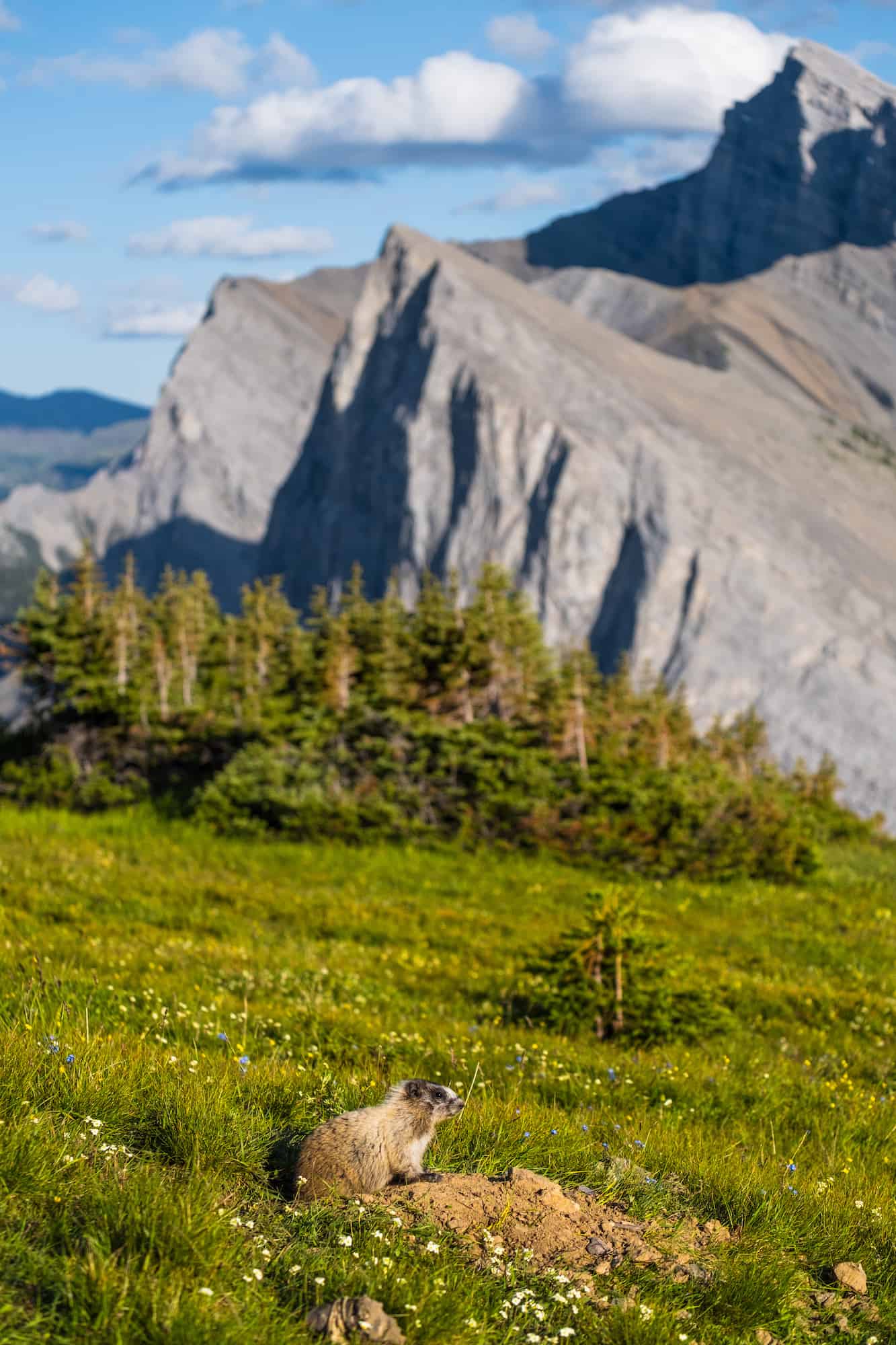
Besides bears, it’s common to see hoary marmots and pika. We asked a marmot for directions, but they only gave us a whistle.
Advice on Hikes in the Canadian Rockies

- If this is your first time hiking in the Rockies take a conservative approach. Pick an adequate hike for your fitness, plan for plenty of time, pack water and food, and don’t be afraid to turn around. If you want to learn more about what to wear hiking we have a great post.
- For long hikes, set a turn around time at the departure. Any time we set out for an objective I determine a time at which we need to turn around in order to arrive at the parking lot or campsite by dark. I would recommend not hiking in the dark as it’s easy to get lost and it’s not fun in bear country.
- Always carry bear spray if you plan to hike in the park. We carry ours in the neighborhood and bears have been known to stroll through town and busy parking lots. Always practice wildlife awareness when you’re on a trail, and please give animals space.
- A GPS tracker could save your life – it’s one of those backpacking essentials I like to have on me just in case I need to hit SOS. We carry the Garmin Inreach Explorer+, but the high cost may not be worth it for the average recreationalist.
- Alltrails is our favorite app to have on a hike. It shows the correct trail way, elevation, and other hiker reviews. We paid the subscription fee so that we could download all the data we need to our phones. It’s certainly not perfect, but it does a great job in the digital space.
What to Wear On a Hike?

The most basic principle of what to wear hiking is layering. Anyone who has spent time in the wilderness or mountains can attest that temperatures can fluctuate widely during a hike. You can easily start cool at the mountain base and get hot as soon as you move.
The goal of hiking clothing is to help regulate your body temperature, protect you from the elements, and manage moisture. Temperature management is best done through a layering system.
Other Kananaskis Country Hikes

There are many more great hikes in the Kananaskis Country, or you can check out some awesome Banff hikes. Both are home to some of our all-time favorite hikes and scrambles in the region.
Plan Your Trip to the Canadian Rockies

If you’re heading to Western Canada soon make sure to check out our interactive map with over 450 spots to help you plan!
- ✅ Hiking trails with links to trails & insider tips you won’t find online
- ✅ Our favorite photo spots, scenic views, waterfalls, must-visit attractions, and even swimming holes
- ✅ Our favorite restaurants, coffee shop & local spots that many skip.
- ✅ We add as we explore ourselves. That means we add new points every month!
- ✅ Map works with Google Maps!
- ✅ Pre built itineraries you can replicate,
- ✅ Discover spots via an ad-free interactive map and a grid, full of original content and videos
- ✅ Use on the go, mobile-first, offline-friendly, and made for the road.
- ✅ Local insights you won’t find on Google or AI – all in one place!


Were you the dude yesterday that runs ha ling in under 90 mins?!
What an incredible guide! The tips on navigating the trail were super helpful, and the photos really captured the beauty of Ha Ling Peak. I can’t wait to tackle this hike myself!